ORTANA
 
  • Control Centers are designed in order to manage and control the ring roads of large cities, main artery of the access roads and tunnels.
  • Integrated management of the data collection equipment and variable message signs is one of the main function of a control center. Video display and processing systems can also be integrated to this structure. In addition to that toll collection systems, radio broadcasts and a variety of security systems can be integrated.
  • Geographic Information System Map (GIS-MAP) softwares simplify monitoring and control applications by a user-friendly interface.
  • Inform the drivers automatically and instaneously about;
    • Traffic Situation
    • Weather Forecast
    • Road Condition
    • Speed Limits
    • Warnings and Routing Information


  • Event Detection Systems: Accidents, Malfunctions, Road Worksı, Weather Conditions etc...
  • Improve the General Traffic Conditions
  • Provide maximum performance both economically and technically
  • Integrable with other systems
 

Travelling Times

  • Travel time between specified locations can be calculated by system algorithm via instantaneous capacity and speed limits of Highways and data obtained from the monitoring and control systems;,
  • Estimated Travelling Speed, Traffic Flow Rate, Traffic Volume can be estimated by computing the traffic data
  • Filtering Structures are used to provide the consistency of calculated time data
  • Instantaneously Updating
  • 100% Automatic Processing
  C15
 

C17

 •   New Generation Software Applications and Designs

 •   Related and scalable Database, Oracle

 •   User manual Integration

 •   Critical algorithm design for ventilation and fire

alarm systems

 •   Audio, Video and Data Integration

 •   Automatic, semi-automatic and manual

 •   Integration with the priority system of rules

 •   Multicentre and multi-tunnel systems

 •   CCTV and Automatic Incident Detection


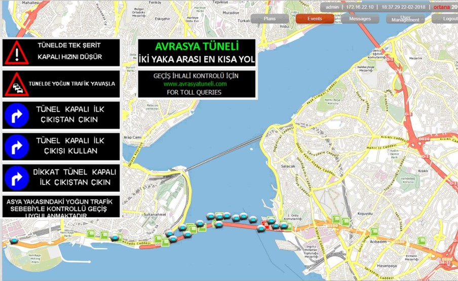
COSMOS-GEOGRAPHIC INFORMATION SYSTEMS CONTROL SOFTWARE

  • Management of city entries - city outs, traffic lane closures and opennings can be controlled by remotely via variable traffic signs and variable message signs for Urban and intercity Highways, Tunnels and Specified Ways
  • Entire Traffic System can be controlled securely and in a way of remote control by GIS Software that consist of web based modules and security protocols
  • Entire Traffic System can be changed one condition to other instantaneously and automatically via Event and Plan Modules (Emergency Road Closure Plan, Icy Road Plan etc...)